
 ORIGINAL: Red Canyon Outlines Drill Plans for Its 100% Owned Osiris Copper-Gold Project
2026-01-26 06:30 ET – News Release
(via TheNewswire)
 |
|||||||||
 |
 |
 |
|||||||
Red Canyon Outlines Drill Plans for Its 100% Owned Osiris Copper-Gold Project
Vancouver, British Columbia , – TheNewswire – January 26, 2026: Red Canyon Resources Ltd. (“Red Canyon” or the “Company”) (CSE: REDC | OTCQB: REDRF) is pleased to provide exploration plans for its 100% owned 1 Osiris copper–gold project in central British Columbia. Red Canyon has expanded data compilation using new and historic geochemical and geophysical datasets and has outlined next steps, including the drill testing of priority targets and plans for additional targets to be upgraded with follow-up work in early 2026.
Company Highlights:
- The Osiris project has altered, mineralized porphyry intrusions with the potential to host multiple copper-gold porphyry centres. Osiris targets are located in the Mesozoic-aged Quesnellia island arc terrane, 35 km west-southwest of Centerra Gold’s Mount Milligan copper-gold mine.
- Expanded work programs in 2025 and detailed compilation and modelling work has solidified exploration plans for early 2026, including a 2,500 m diamond drill program testing priority drill targets at the Camp target. Furthermore, an up to 1,500 m of reverse circulation (“RC”) drill program is planned to test multiple, never tested under-cover targets.
- Studies, including four-acid geochemistry of historic drill core, new airborne geophysical surveys (magnetics and radiometrics), magnetic vector inversion (MVI) modeling and re-interpretation of historic IP geophysics, have been completed and compiled. This work highlighted additional targets for drill testing and follow-up exploration.
- Historic drill hole 91-2 from the Camp target returned 0.18% copper plus anomalous gold over 127.4 m. The Company interprets this intercept as being located peripheral to the central part of a copper-gold porphyry system. The Camp target is open laterally and at depth and is our top priority drill target for early 2026.
- The Company is progressing with plans for additional work at the Acheron project at Inzana and at our Kendal porphyry copper discovery in west-central British Columbia. Scraper Springs in Nevada is also drill ready with multiple copper-gold drill targets in one of the world’s largest hydrothermal alteration systems.
Wendell Zerb, the Chairman and CEO of the Company, commented: “ The Inzana area, which hosts our Osiris project, has become high priority within the overall Red Canyon portfolio. We recognized this area for its copper–gold potential based on its intriguing geological setting and underexplored potential. Interpreted large-scale cross-arc structures, recognized fertile geological terrane, outstanding access and quality historic work have never previously been followed-up with new modern geoscience advances. Modeling has refined priority copper-gold porphyry targets at the Camp target and several new, never drill tested targets are in queue for follow-up work. We’re excited to drill test the Camp target based on our new exploration perspectives of these important historical results, including a drill intercept of 127.4 metres grading 0.18% Cu. Based on other well-documented alkalic copper-gold mineral systems, including the Cadia Ridgeway mineral system, we believe this historic drill intercept could be peripheral to economic copper–gold grades at Camp.”
Overview of Red Canyon Projects:
The Company holds a portfolio of seven 100% owned 1 projects in British Columbia and Nevada. High priority projects are Kendal in west-central British Columbia, Inzana (Osiris and Acheron) in central British Columbia and Scraper Springs in northeast Nevada. The Company continues to review new early stage to advanced stage mineral projects within the Western United States and British Columbia.
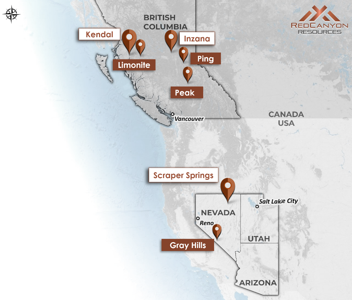
Click Image To View Full Size
Figure 1: Location map o f Red Canyon’s 100% owned 1 copper and copper-gold projects.
Inzana Project Area:
The Inzana project area is located in central British Columbia, approximately 60 km northwest of the district municipality of Fort St. James and 35 km west-southwest of Centerra Gold’s Mount Milligan Cu-Au mine (Figure 2). The Company staked 14,908 hectares of mineral claims within the Inzana project area that are 100% owned and royalty-free. The Company has also entered into property option agreements to acquire a 100% interest in an additional two mineral claims at Osiris and two mineral claims at Acheron, totalling 539 hectares, for total consideration of $48,000 payable over a three-year term. Each two optioned mineral claims at Osiris and Acheron are subject to a 1.25% net smelter return royalty, of which 100% may be purchased for $2 million at any time.
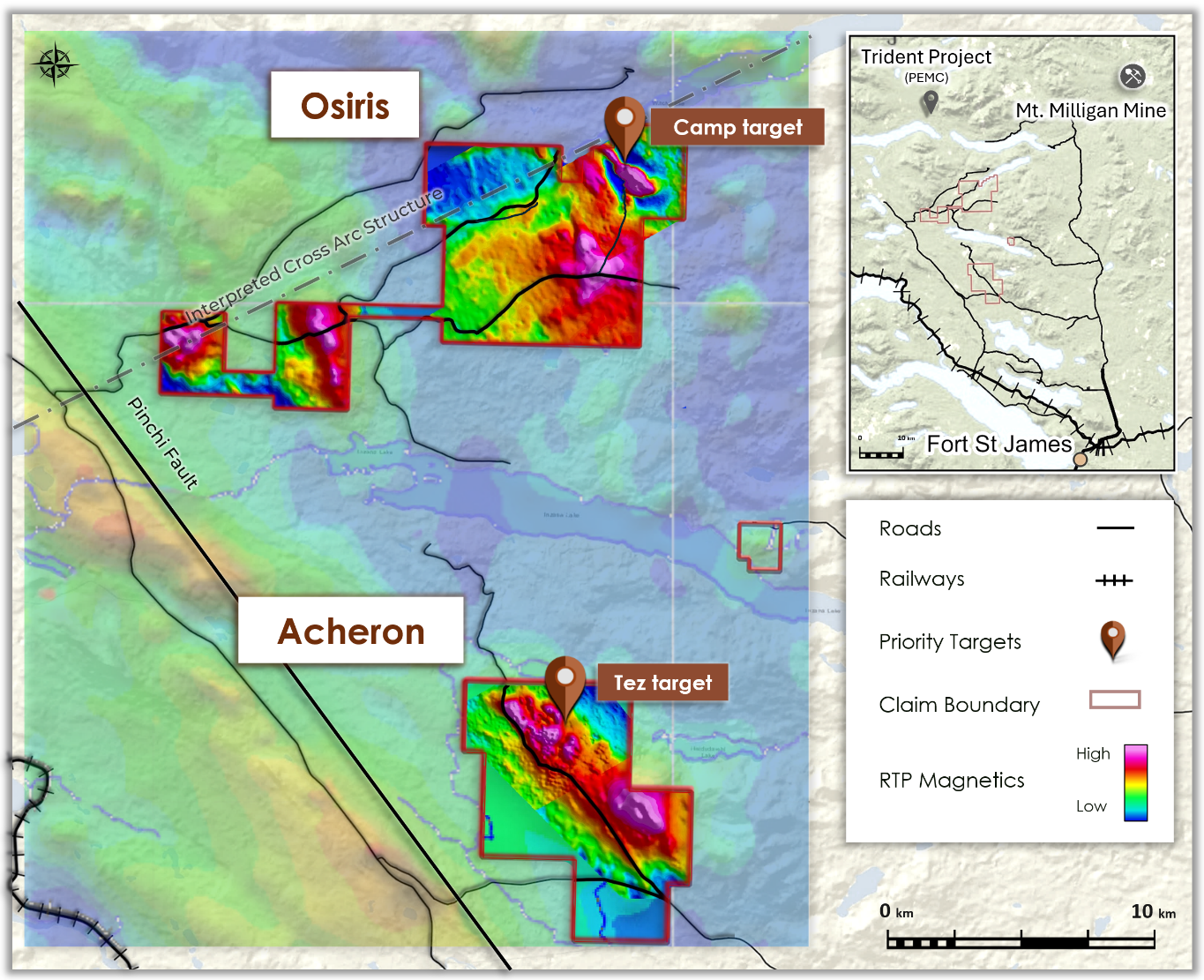
Click Image To View Full Size
Figure 2: Inzana project area, outlining Osiris and Acheron projects and Camp and Tez targets.
The project area is located within the early Mesozoic-aged Quesnellia island arc terrane that occupies much of east-central British Columbia and is host to several of the province’s largest copper mines . The project area is bounded to the west by the NW-trending Pinchi Fault which juxtaposes older Cache Creek Terrane with the Triassic-Jurassic Quesnellia Terrane. The Company interprets that a NE-SW cross-arc structure is located on the northern boundary of the Osiris project area. Cross-arc structures are well documented to be important structural pathways for the localization of porphyry deposits in arc terranes worldwide.
Red Canyon believes the Osiris and Acheron areas have excellent potential to host potentially economic copper-gold porphyry systems and that previous work identified alkalic porphyry alteration and mineralization indicative of peripheral zones to the main porphyry centres. The area hosts various porphyritic intrusive rocks, anomalous copper, molybdenum and gold geochemistry as well as magnetite-rich hydrothermal alteration related to alkalic porphyry copper systems. A series of intermittent work programs spanning over 50 years has included geological mapping, geochemistry, magnetics, IP geophysics and diamond drilling.
Osiris Project
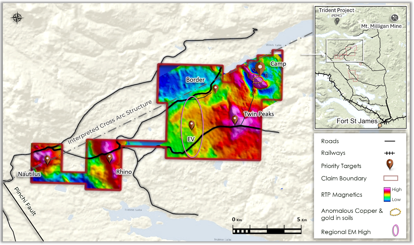
Click Image To View Full Size
Figure 3: Osiris project, outlining priority targets for 2026 field work and the Camp target location.
New magnetic data over the Osiris project indicates multiple magnetic features bound to the west by the Pinchi Fault and adjacent to an interpreted cross-arc structure. Forestry activity in the area has significantly improved road access throughout the area.
Red Canyon has completed work programs including selective rock, soil and till sample geochemistry, four-acid geochemistry of historic drill core samples, project-wide airborne magnetics and radiometrics and Magnetic Inversion Modeling (MVI). Based on these programs several new zones of interest (Figure 3) have been identified for follow up.
The Company’s 2026 field plans anticipate selective IP and EM geophysics, RC drilling and diamond drilling targets at Camp, and possibly recently identified under-cover targets. The Company has received a Mines Act permit to conduct exploration at Osiris.
Osiris Magnetic Inversion Modeling
Recent work by Red Canyon included project-wide airborne magnetics and radiometrics completed by Precision Geophysics. The Company used Fathom Geophysics to expand the study details, completing standard data filtering and MVI modeling. In addition, Fathom selectively reviewed pipe modelling of specific targets to determine depth to source to refine drill hole planning. These studies have outlined several new targets for follow up.
The Camp target is modeled depicting a highly magnetic body (mapped as an altered biotite feldspar porphyry). A rimming intrusive and altered/mineralized porphyritic andesite or augite porphyry body is interpreted as a remanent magnetic feature. The interpreted intrusive complex expands to depth and trends west-southwest merging with a newly identified undercover target area called Twin Peaks (Figure 4). Geophysical modeling shows a series of smaller pipe-like bodies, possibly porphyry intrusions, coming from the larger interpreted causative intrusion at depth. Depth to source studies on two of the pipe-like intrusions model the top of the intrusions at approximately 90m and 130m below surface. Selective basal till sampling completed in 2025 by Red Canyon show broadly anomalous copper and moly geochemistry associated with this area. Exploration plans in early 2026 include IP geophysics, RC drilling and possible diamond drilling.
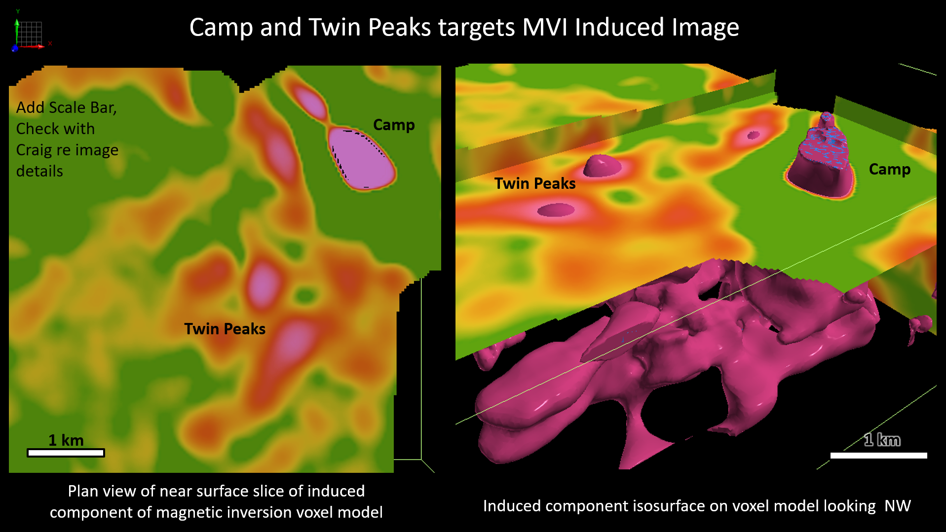
Click Image To View Full Size
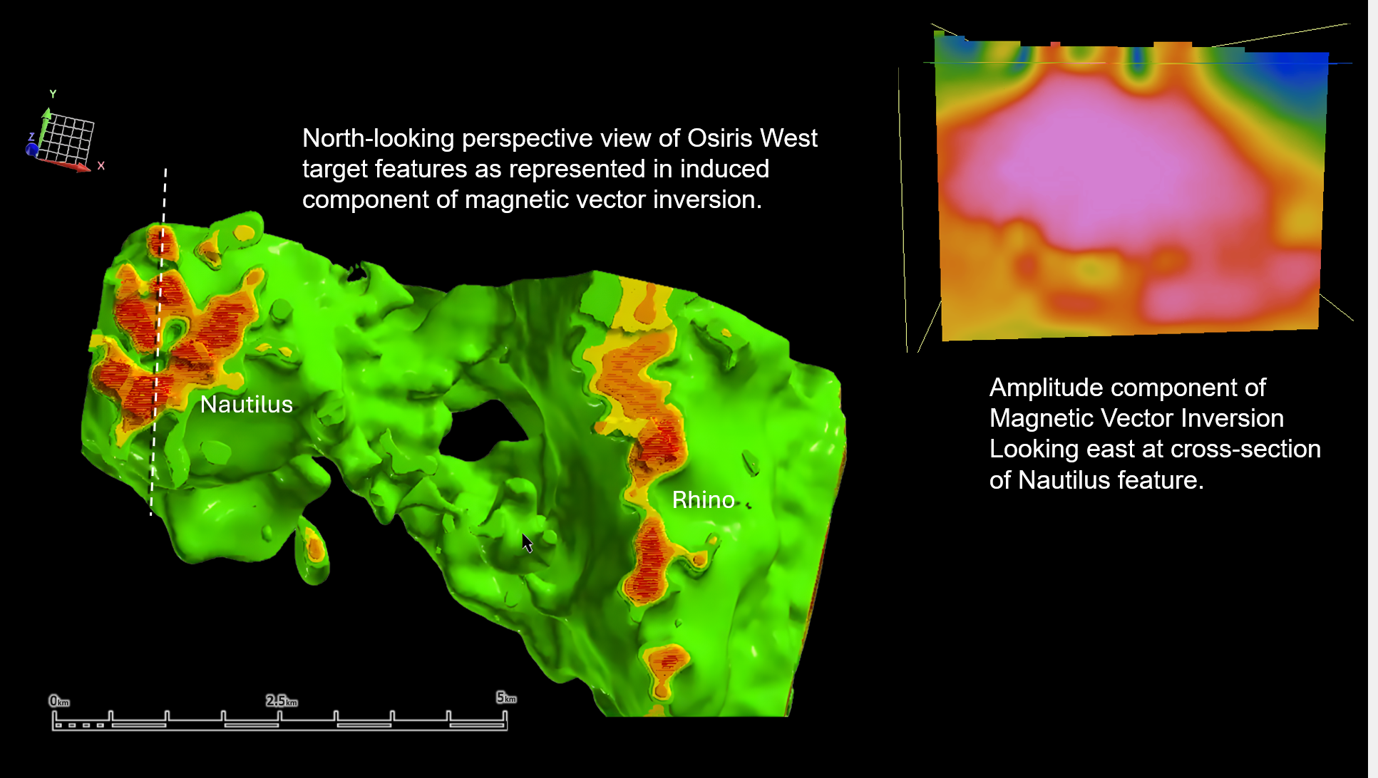
Figure 4: MVI Camp and Twin Peaks on magnetic images.
MVI modeling of the Osiris West area has outlined two large-scale magnetic zones of interest, the Nautilus and Rhino zones host notable magnetic features highlighted by MVI modeling. The Nautilus target area is a circular magnetic feature spanning approximately 3 km by 3 km bounded to the west by the Pinchi fault and to the north by an interpreted west-southwest trending cross-arc structure (Figures 3 and 5). The MVI studies identified multiple, near-surface magnetic pipe-like features, interpreted as possible porphyry intrusions originating from a larger magnetic body, possibly the causative intrusion at depth. Depth-to-source studies on these possible pipe-like intrusions model the top of the intrusion at approximately 50m below surface. Exploration plans in early 2026 include IP geophysics, RC drilling and possible diamond drilling.
The Rhino target is a north-trending linear magnetic feature spanning approximately 2 km by 5 km also bounded to the west by the Pinchi fault and to the north by the interpreted west-southwest trending cross-arc structure (Figures 3 and 5). The MVI studies identified multiple shallow magnetic pipe-like features, interpreted as possible porphyry intrusions, coming from a larger magnetic body, possibly the causative intrusion at depth. Geophysical modeling also identified possible west-northwest structures linking the Nautilus and Rhino target areas. Several secondary targets have been identified along this trend. Exploration plans in early 2026 include IP geophysics, RC drilling and possible diamond drilling.
Click Image To View Full Size
Figure 5: Magnetic Inversion Modeling of Nautilus and Rhino target areas.
Camp Copper-Gold Porphyry Target
The Camp target is associated with a 1.5 km by 2.0 km NNW-trending magnetic high (Figures 3, 4 and 6). Previous work suggests the magnetic high feature is due to introduced highly oxidized alkalic intrusions and associated hydrothermal magnetite .
Click Image To View Full Size
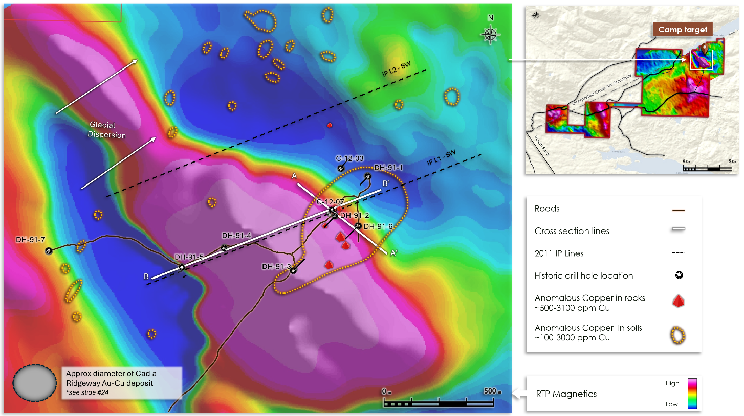
Figure 6: The Camp zone target outlining airborne RTP magnetics, rock and soil geochemistry, historical drill hole locations and for scale the comparative size footprint of Cadia – Ridgeway alkalic Au-Cu deposit .
Click Image To View Full Size
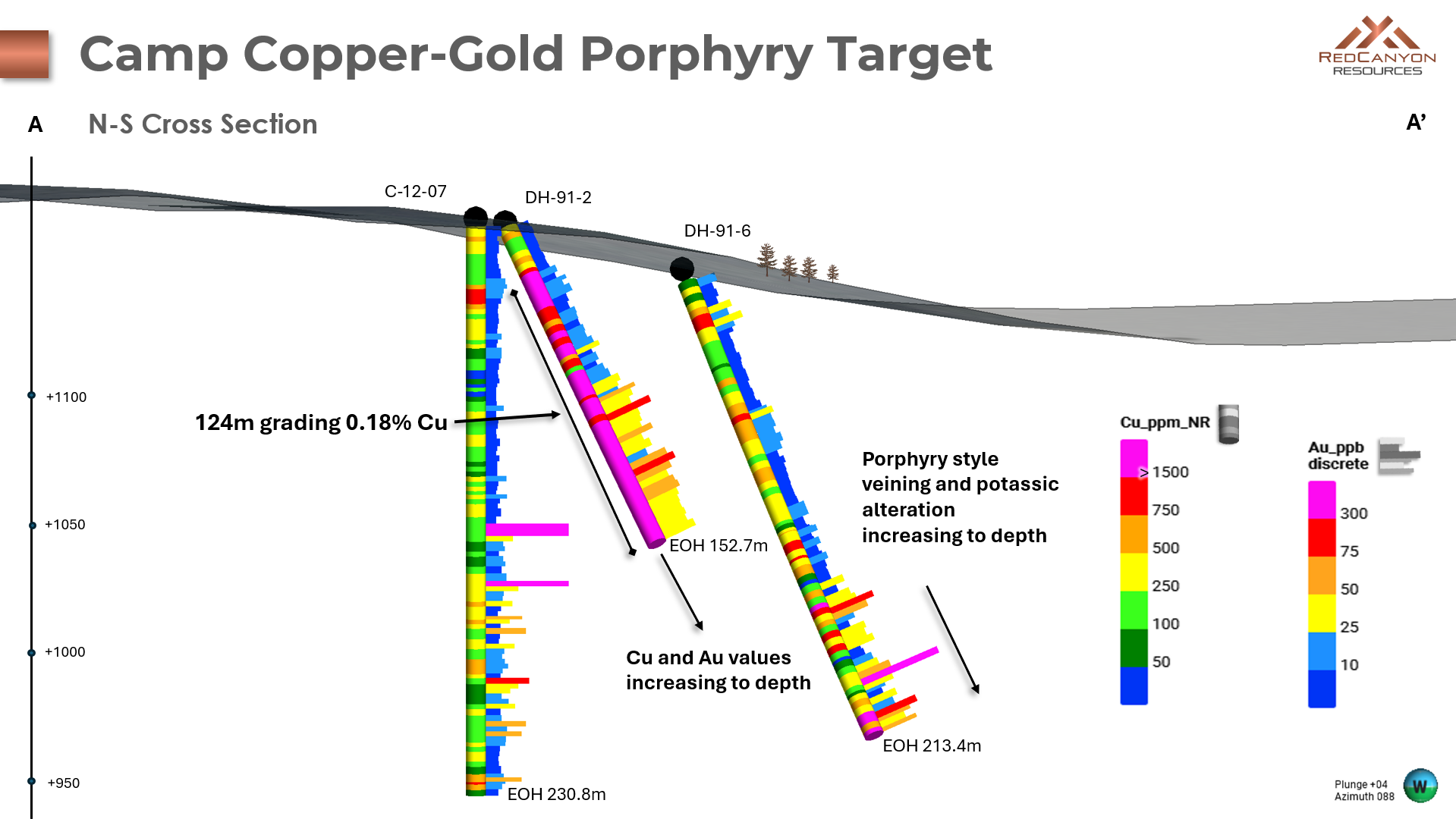
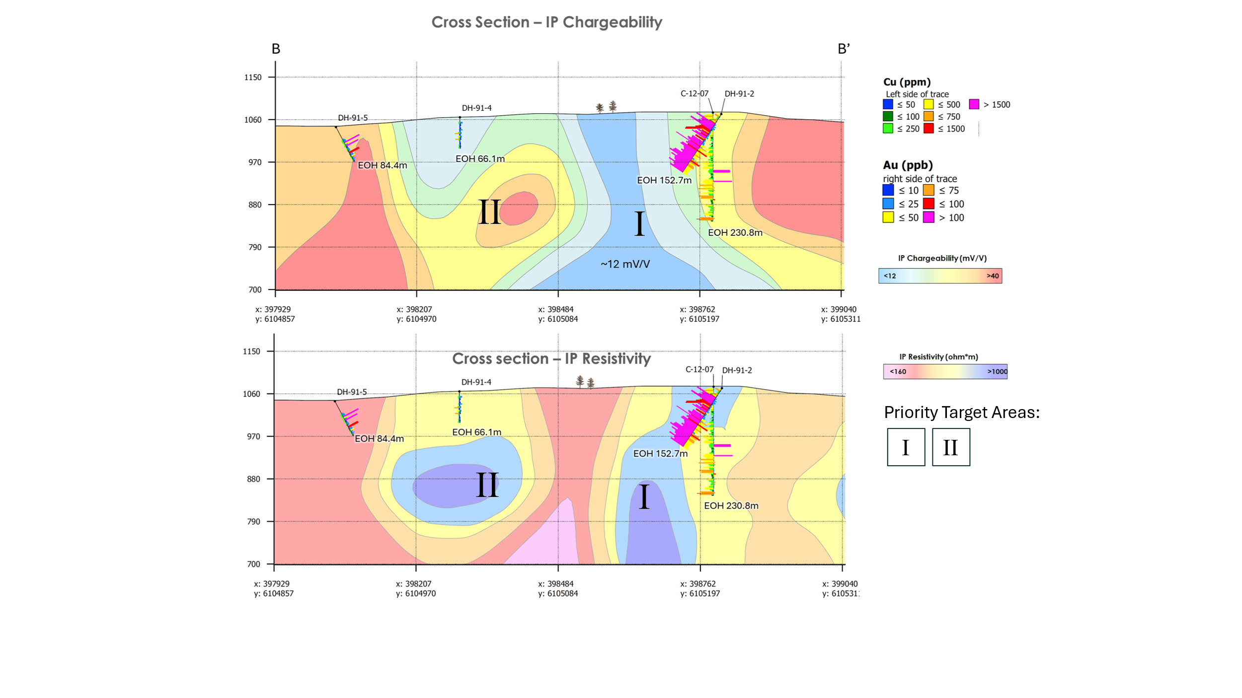
Figure 7: NNW – SSE cross-section outlining historical drill holes with Cu and Au histograms at Camp target.
A series of historical drill holes at Camp (Figures 6 and 7) intersected porphyry-style alteration plus copper and gold mineralization indicative of an alkalic porphyry system. Drill holes 91-2 and 91-6 ended in mineralization with grades of copper and gold increasing to depth. In addition, porphyry-style veining and potassic alteration are interpreted as increasing down hole towards the west (Figure 7).
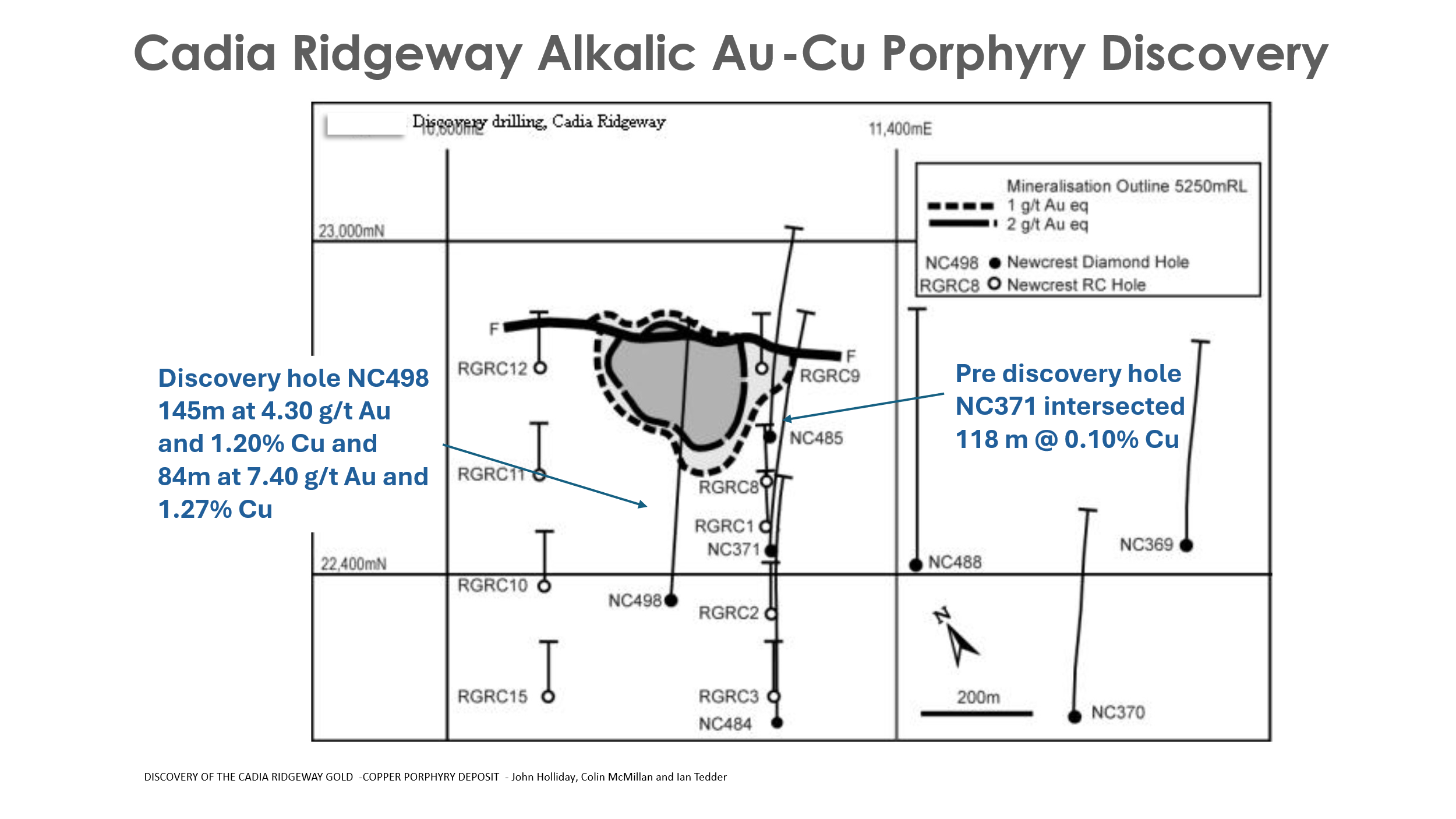
Historic drill hole 91-2 from Osiris returned 0.18% copper with anomalous gold over 127.4 m starting from 25.3 m. Based on the footprint of other known alkalic porphyry deposits worldwide, the Company believes the target area remains open to vector into a potential higher-grade core to the system. As an example, the high grade Cadia Ridgeway alkalic copper gold deposit in New South Wales, Australia is generally a vertically extensive body with an approximately 225 m by 225 m diameter. A Newcrest pre-discovery drill hole (NC371) within 150 m of the discovery hole at Cadia Ridgeway graded 0.10% copper over 118 m (Figure 8), comparable to the copper values in 91-2.
Click Image To View Full Size
Figure 8: * Historic drill plan of Cadia Ridgeway alkalic Au-Cu deposit New South Wales, Australia. Pre-discovery drill hole NC371 was drilled 150 m east of the high-grade discovery drill hole NC498.
The Company believes the hydrothermal system at Camp is open along the magnetic high as it trends NNW to SSE (Figure 6). The underlying rocks along the magnetic high trend are the potential source of the elevated copper in soil/till geochemistry glacially dispersed to the north (Figure 6). In addition, previous drill holes testing this margin are highly altered and mineralized augite porphyritic rocks or hornfels sediments. Quartz veins with increasing sericite and biotite alteration downhole are common, suggesting a possible trend toward the potassic core of the system. IP chargeability and resistivity data indicates that highly chargeable zones could potentially correlate with altered intrusions or graphic sediments in parts of the Camp area. The north-trending high resistivity feature is interpreted as a potassic altered zone potentially correlating with the more central part of the porphyry system (Figure 9).
Click Image To View Full Size
Figure 9: West – East IP chargeability and resistivity cross-section outlining historical drill holes with Cu and Au histograms and priority drill targets . See section line B- B’ Figure 6.
Acheron Project
The Acheron project at Inzana is defined by a NW-trending magnetic high spanning 10 km by up to 2.5 km. Historic exploration work identified multiple phases of hydrothermally altered and mineralized porphyritic intrusions (Figure 2).
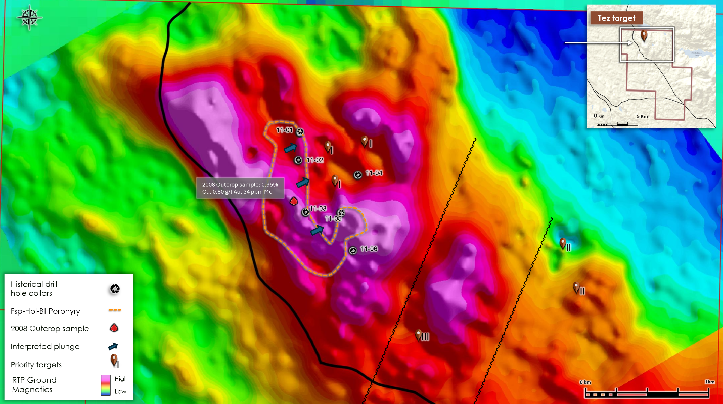
The Tez target at Acheron is interpreted by Red Canyon to be a calc-alkaline porphyry centre defined by complex magnetics, rock and soil geochemistry, and shallow historical drilling. Soil sample geochemistry and historic drilling outline a core zone of elevated Cu, Mo and Au. Outbound to this area is a rimming zone of elevated As and Mn, all indicative of chemistry that outlines the central signature of a porphyry system.
Red Canyon has completed additional work programs including selective rock, soil and till geochemistry, geological mapping, four-acid geochemistry of historic drill core, project wide airborne magnetic and radiometric surveys and MVI modeling. Based on these programs several preliminary new zones of interest have been identified for follow up exploration including new target areas at Tez (Figure 10). Additional studies meshing ioGas modeling of four-acid geochemistry with new MVI interpretation and IP geophysics is ongoing. Preliminary interpretation suggests an early feldspar-hornblende-biotite porphyry is an important, early mineralized intrusive phase at Tez. The interpreted hottest portion of the system is on the northern portion of the Tez area where historic drilling is interpreted to indicate that the intrusion is potentially tilted or plunging easterly. In addition, ioGas studies suggest drilling at Tez encountered the upper parts of the system indicating the copper zone remains at depth.
Click Image To View Full Size
Figure 10: Tez target area – RTP magnetics with interpreted geology, historic drill holes and new target areas.
Following completion of compilation studies follow-up work is anticipated in 2026, potentially including RC and diamond drilling.
About Red Canyon Resources
Red Canyon Resources Ltd. (CSE: REDC | OTCQB: REDRF) is a geoscience-driven, discovery-focused mineral exploration company focused on exploring North America’s top copper jurisdictions. The Company’s core goal is to make impactful copper discoveries. Red Canyon has a portfolio of 100% owned copper and copper-gold porphyry exploration projects. The Company’s technical team consists of experienced geoscientists with diverse capital market, small cap and major mining company backgrounds and a track record of success.
For more information, please visit the Company’s website at www.redcanyonresources.com .
Red Canyon is part of the NewQuest Capital Group which is a discovery-driven investment group that builds value through the incubation and financing of mineral projects and companies. Further information about NewQuest can be found on the company website at www.nqcapitalgroup.com .
1 Red Canyon has two projects subject to option earn in agreements whereby the Company can earn into 100% of the project.
* Source: DISCOVERY OF THE CADIA RIDGEWAY GOLD-COPPER PORPHYRY DEPOSIT – John Holliday, Colin McMillan and Ian Tedder – SMEDG.org.au
On Behalf of the Board of Directors
Wendell Zerb, P. Geol
Chairman and Chief Executive Officer
+1 (604) 681-9100
For further information, please contact:
Brennan Zerb
Investor Relations Manager
+1 (778) 867-5016
The Canadian Securities Exchange does not accept responsibility for the adequacy or accuracy of this press release.
Qualified Person :
The technical information contained in this update has been reviewed and approved by Wendell Zerb, P. Geol, a “Qualified Person” (“QP”) as defined in National Instrument 43-101 – Standards of Disclosure for Mineral Projects. Mr. Zerb is not independent by reason of being the Chairman, President and CEO of the Company. In presenting examples in this release for comparison including the Cadia mine in New South Wales, Australia, the Company in no way implies that future exploration will necessarily result in the discovery of similar economic mineral deposits. *The qualified person has not verified the information on theses deposits and the information disclosed is not necessarily indicative of mineralization on Red Canyon projects.
Forward-Looking Statements:
This news release includes certain forward-looking statements and forward-looking information (collectively, “forward-looking statements”) within the meaning of applicable Canadian securities legislation. All statements, other than statements of historical fact, included herein including, without limitation, statements regarding future capital expenditures, exploration activities and the specifications, targets, results, analyses, interpretations, benefits, costs and timing of them, and the anticipated business plans and timing of future activities of the Company, are forward-looking statements. Although the Company believes that such statements are reasonable, it can give no assurance that such expectations will prove to be correct. Often, but not always, forward looking information can be identified by words such as “pro forma”, “plans”, “expects”, “may”, “should”, “budget”, “scheduled”, “estimates”, “forecasts”, “intends”, “anticipates”, “believes”, “potential” or variations of such words including negative variations thereof, and phrases that refer to certain actions, events or results that may, could, would, might or will occur or be taken or achieved. Forward-looking statements involve known and unknown risks, uncertainties and other factors which may cause the actual results, performance or achievements of the Company to differ materially from any future results, performance or achievements expressed or implied by the forward-looking statements. Such risks and other factors include, among others, risks related to the anticipated business plans and timing of future activities of the Company, including the Company’s exploration plans and the proposed expenditures for exploration work thereon, the ability of the Company to obtain sufficient financing to fund its business activities and plans, the ability of the Company to obtain the required permits, changes in laws, regulations and policies affecting mining operations, the Company’s limited operating history, currency fluctuations, title disputes or claims, environmental issues and liabilities, as well as those factors discussed under the heading “Risk Factors” in the Company’s prospectus dated October 12, 2023 and other filings of the Company with the Canadian Securities Authorities, copies of which can be found under the Company’s profile on the SEDAR+ website at www.sedarplus.ca.
Readers are cautioned not to place undue reliance on forward-looking statements. The Company undertakes no obligation to update any of the forward-looking statements, except as otherwise required by law.
Copyright (c) 2026 TheNewswire – All rights reserved.
https://www.redcanyonresources.com/
Related Posts
Tags
Share This


