 ORIGINAL: Noble Minerals Announces Drilling Results from Noble Minerals-Canada Nickel Joint Venture
2024-10-31 07:31 ET – News Release
(via TheNewswire)
 |
|||||||||
 |
 |
 |
 |
 |
|||||
Highlights
- Drill Program completed on the Mann and Reaume Properties, part of the Noble Minerals-Canada Nickel Joint Venture (ExploreCo)
- Mann Central Property: Drill results include 223 meters of 0.29% nickel including 10 meters of 0.51% nickel
- Mann West Property: Drilling successfully delineated mineralization over a 1,700 meter strike length and 600 meters width
- First assays from 2024 drilling at Mann West yield excellent results including 330 metres of 0.26% nickel in MAN24-58 including a total of 24.5 metres of 0.35% nickel; initial resource estimate expected by Q1 2025
- Multiple gold intervals in Mann North drilling including 4.5 metres of 2.36 g/t gold within 45 metres of 0.45 g/t gold at MAN24-67
- Reaume Property: Drilling indicated an improved nickel grade
Toronto, Ontario – TheNewswire – October 31, 2024 – Noble Mineral Exploration Inc. ( “Noble” or the “Company” ) (TSX-V:NOB, FRANKFURT: NB7, OTCQB:NLPXF) is pleased to announce results of a drill program on joint venture properties (ExploreCo) north of Timmins Ontario (See Canada Nickel Press Release dated October 31, 2024).
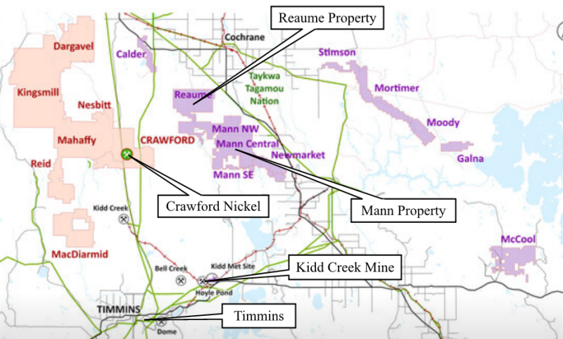
ExploreCo, the name of which will be announced in due course, will control 1,989 mining claims totaling approximately 42,000 hectares and will include nickel properties in Mann, Newmarket, and Reaume Townships as well as Calder, Galna, McCool, Moody, Mortimer, Stimson, and other properties currently held by Canada Nickel (see Figure 1, ExploreCo properties shown in purple).
Figure 1 – Regional Map of ExploreCo Properties (purple)
Under the Binding Letter of Intent, the first $5 million of funding for ExploreCo will be provided from existing funds by Canada Nickel, after which costs will be funded by pro rata ownership basis, which will initially be 80% Canada Nickel and 20% Noble. Canada Nickel and Noble will continue to maintain their existing royalty rights on the ExploreCo claims, as will previous claim owners who had vended claims to Noble. (see NR July 8, 2024)
Mann Property
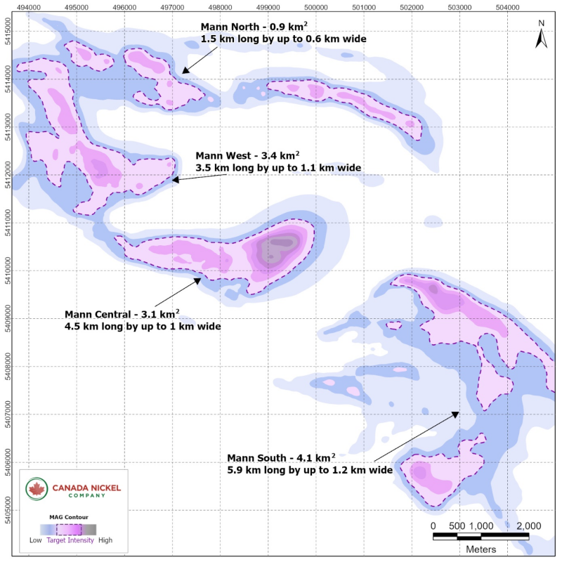
The Mann property is located 22 kilometres east of Crawford between Timmins and Cochrane. The Company has completed a drill program in three of the four identified areas within the property, Mann North, Mann West (together formerly Mann Northwest), and Central. (Figure 2). Exploration at Mann South is currently underway. Canada Nickel currently owns 80% of the Mann Property after successfully completing an earlier earn-in agreement with Noble Mineral Exploration. This property is part of the creation of an ‘ExploreCo’ subsidiary with Noble Mineral Exploration (see press release July 8, 2024) with Noble owning the other 20%.
Figure 2 – Mann Property
Mann West
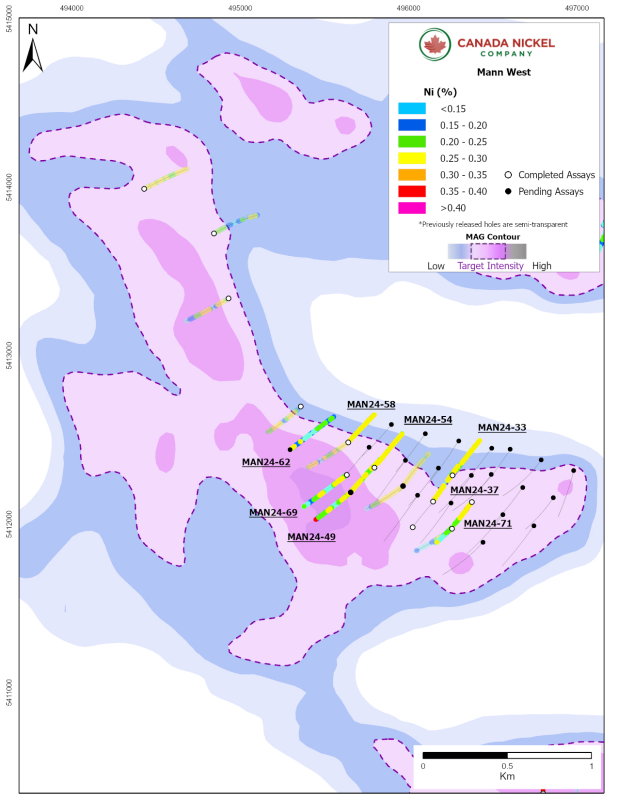
Mann West is approximately 3.5 kilometres long by up to 1.1 kilometres wide (covering 3.4 square kilometres). The drill program has focused on the southern half of the target with drilling completed over a strike length of 1.7 kilometres and a width of at least 600 metres. All drillholes intersected long sections of well-serpentinized peridotite and minor dunite with disseminated and visible nickel sulphide mineralization consisting primarily of pentlandite and heazlewoodite. The Company has drilled 40 holes to date at Mann West (Figure 3), 31 of which were drilled during the 2024 program. With this drilling, the Company has completed the first phase of exploration that is required for an initial resource estimate expected by Q1 2025. Assays from nine holes are presented in this release, with the remaining holes at Mann West still pending.
Table 2 – Mann West drilling highlights.
| Hole ID | From (m) | To (m) | Length (m)* | Ni % | Co % | Pd g/t | Pt g/t | Cr % | Fe % | S % |
| MANN WEST | ||||||||||
| MAN24-33 | 11.2 | 396.0 | 384.8 | 0.24 | 0.011 | 0.009 | 0.008 | 0.35 | 6.48 | 0.028 |
| including | 174.0 | 183.0 | 9.0 | 0.30 | 0.014 | 0.018 | 0.011 | 0.18 | 6.34 | 0.100 |
| MAN24-37 | 8.7 | 180.0 | 171.3 | 0.26 | 0.011 | 0.005 | 0.006 | 0.15 | 6.04 | 0.037 |
| and | 236.4 | 402.0 | 165.6 | 0.26 | 0.012 | 0.008 | 0.007 | 0.24 | 6.26 | 0.071 |
| including | 267.0 | 273.0 | 6.0 | 0.37 | 0.013 | 0.004 | 0.005 | 0.30 | 7.73 | 0.100 |
| and | 361.5 | 369.0 | 7.5 | 0.38 | 0.013 | 0.078 | 0.043 | 0.18 | 6.35 | 0.162 |
| MAN24-45 | 6.2 | 402.0 | 395.8 | 0.24 | 0.013 | 0.016 | 0.010 | 0.39 | 6.60 | 0.235 |
| including | 136.5 | 144.0 | 7.5 | 0.30 | 0.014 | 0.044 | 0.015 | 0.75 | 6.99 | 0.086 |
| MAN24-49 | 5.4 | 198.2 | 192.8 | 0.19 | 0.013 | 0.029 | 0.017 | 0.41 | 7.44 | 0.081 |
| and | 221.6 | 402.0 | 180.4 | 0.21 | 0.011 | 0.003 | 0.006 | 0.42 | 6.69 | 0.033 |
| MAN24-54 | 49.5 | 192.8 | 143.3 | 0.26 | 0.011 | 0.003 | 0.003 | 0.13 | 5.80 | 0.045 |
| and | 216.5 | 402.0 | 185.5 | 0.27 | 0.012 | 0.012 | 0.007 | 0.28 | 6.22 | 0.029 |
| including | 268.5 | 277.5 | 9.0 | 0.48 | 0.019 | 0.003 | 0.003 | 0.62 | 7.86 | 0.015 |
| MAN24-58 | 21.0 | 351.0 | 330.0 | 0.26 | 0.013 | 0.015 | 0.007 | 0.24 | 6.51 | 0.076 |
| including | 193.5 | 204.5 | 11.0 | 0.35 | 0.015 | 0.023 | 0.009 | 0.44 | 6.86 | 0.110 |
| and | 307.5 | 321.0 | 13.5 | 0.36 | 0.016 | 0.040 | 0.018 | 0.19 | 7.17 | 0.130 |
| MAN24-62 | 8.6 | 501.0 | 492.4 | 0.18 | 0.014 | 0.041 | 0.026 | 0.31 | 7.88 | 0.047 |
| MAN24-69 | 7.2 | 229.5 | 222.3 | 0.19 | 0.013 | 0.022 | 0.015 | 0.38 | 7.35 | 0.054 |
| and | 264.0 | 491.0 | 227.0 | 0.19 | 0.013 | 0.004 | 0.005 | 0.41 | 7.35 | 0.023 |
| MAN24-71 | 23.5 | 260.5 | 237.0 | 0.27 | 0.012 | 0.011 | 0.009 | 0.25 | 6.29 | 0.082 |
| including | 63.0 | 108.0 | 45.0 | 0.37 | 0.013 | 0.036 | 0.018 | 0.15 | 5.77 | 0.196 |
| and | 302.2 | 501.0 | 198.8 | 0.17 | 0.012 | 0.014 | 0.032 | 0.36 | 7.56 | 0.027 |
*True width undetermined. All lengths are drillhole lengths.
Figure 3 – Mann West
Mann Central
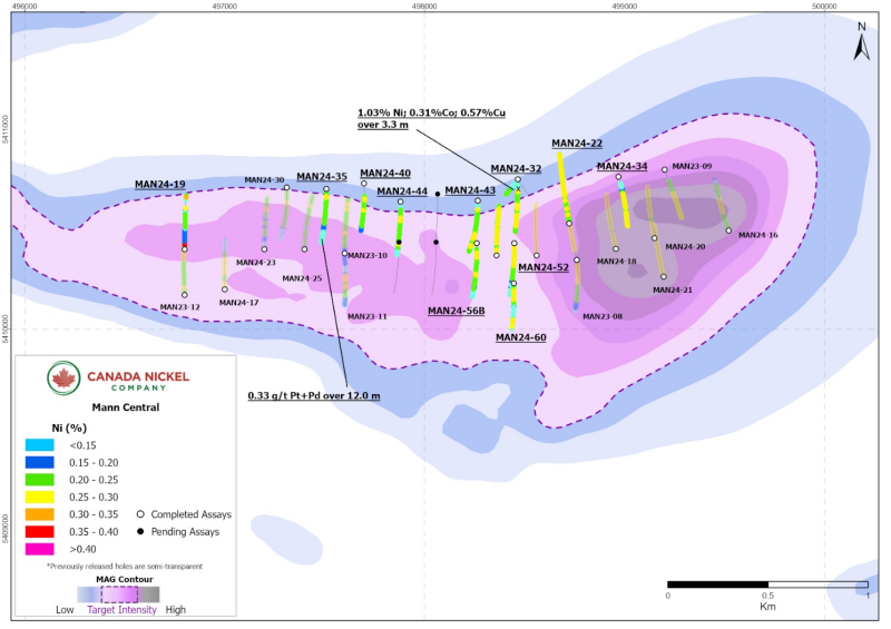
The outline of the ultramafic body at Mann Central is estimated by magnetics to be 4.5 kilometres long and between 0.5 to 1.0 kilometres wide (or 3.1 square kilometres). Drilling at this target was completed during the spring/summer of 2024 and now totals 32 drillholes and 11,853 metres. Mineralization is more consistent near the center of the target over an area of 1.9 kilometres by 600 metres (1.1 square kilometres). This release provides an update for 13 drillholes (Table 3), all of which intersected varying degrees of mineralized peridotite with minor pyroxenite dykes.
Mafic volcanics with abundant sulphide mineralization in the north contact were intersected in eight holes including MAN24-32 which yielded 3.3 metres of 1.03% nickel, 0.31% cobalt, and 0.57 % copper. Assays are still pending for 10 drillholes and the results from nine drillholes were previously released (see press release September 10, 2024).
Table 3 – Mann Central drilling highlights.
| Hole ID | From (m) | To (m) | Length (m)* | Ni % | Co % | Pd g/t | Pt g/t | Cr % | Fe % | S % |
| MAN24-19 | 3.0 | 304.0 | 301.0 | 0.18 | 0.012 | 0.008 | 0.006 | 0.42 | 7.36 | 0.037 |
| and | 384.0 | 396.8 | 12.8 | 0.18 | 0.010 | 0.003 | 0.008 | 0.33 | 6.29 | 0.083 |
| MAN24-22 | 9.0 | 552.0 | 543.0 | 0.24 | 0.012 | 0.005 | 0.006 | 0.17 | 5.90 | 0.057 |
| Including | 195.0 | 207.0 | 12.0 | 0.29 | 0.013 | 0.022 | 0.008 | 0.14 | 5.66 | 0.082 |
| MAN24-26 | 12.0 | 55.5 | 43.0 | 0.25 | 0.011 | 0.003 | 0.008 | 0.18 | 5.85 | 0.101 |
| and | 100.5 | 399.0 | 298.5 | 0.23 | 0.011 | 0.004 | 0.003 | 0.16 | 6.22 | 0.052 |
| MAN24-32 | 90.0 | 402.0 | 312.0 | 0.21 | 0.015 | 0.004 | 0.004 | 0.27 | 6.42 | 0.121 |
| including | 96.0 | 99.3 | 3.3 | 1.03 | 0.308 | 0.026 | 0.013 | 0.14 | 19.78 | 4.840 |
| MAN24-34 | 75.0 | 259.0 | 184.0 | 0.22 | 0.011 | 0.008 | 0.008 | 0.31 | 6.79 | 0.044 |
| and | 297.0 | 402.0 | 105.0 | 0.24 | 0.011 | 0.007 | 0.008 | 0.22 | 5.97 | 0.080 |
| MAN24-35 | 25.2 | 144.3 | 119.1 | 0.22 | 0.012 | 0.003 | 0.004 | 0.24 | 6.74 | 0.051 |
| and | 161.0 | 387.0 | 226.0 | 0.18 | 0.013 | 0.005 | 0.006 | 0.40 | 7.39 | 0.030 |
| MAN24-39 | 97.5 | 171.0 | 73.5 | 0.19 | 0.011 | 0.007 | 0.007 | 0.45 | 7.28 | 0.049 |
| MAN24-40 | 103.3 | 153.0 | 49.7 | 0.24 | 0.012 | 0.004 | 0.004 | 0.26 | 6.10 | 0.071 |
| and | 141.0 | 396.0 | 255.0 | 0.21 | 0.012 | 0.005 | 0.005 | 0.41 | 7.05 | 0.031 |
| MAN24-43 | 76.7 | 182.4 | 105.7 | 0.22 | 0.012 | 0.005 | 0.006 | 0.22 | 6.37 | 0.114 |
| and | 205.4 | 402.0 | 196.6 | 0.23 | 0.012 | 0.003 | 0.005 | 0.38 | 6.56 | 0.033 |
| MAN24-44 | 43.0 | 186.7 | 143.7 | 0.21 | 0.011 | 0.004 | 0.004 | 0.30 | 6.65 | 0.029 |
| and | 195.0 | 402.0 | 207.0 | 0.19 | 0.013 | 0.005 | 0.007 | 0.415 | 7.176 | 0.030 |
| MAN24-52 | 11.4 | 46.7 | 35.3 | 0.31 | 0.037 | 0.003 | 0.006 | 0.169 | 5.794 | 0.176 |
| and | 73.0 | 400.0 | 327.0 | 0.20 | 0.013 | 0.004 | 0.005 | 0.390 | 6.779 | 0.028 |
| MAN24-56B | 45.0 | 402.0 | 357.0 | 0.20 | 0.013 | 0.003 | 0.005 | 0.411 | 7.126 | 0.022 |
| MAN24-60 | 31.9 | 241.2 | 209.3 | 0.20 | 0.013 | 0.007 | 0.007 | 0.369 | 6.920 | 0.060 |
| and | 277.5 | 310.9 | 33.4 | 0.26 | 0.015 | 0.003 | 0.004 | 0.055 | 8.981 | 0.057 |
*True width undetermined. All lengths are drillhole lengths.
Figure 4 – Mann Central
Mann North
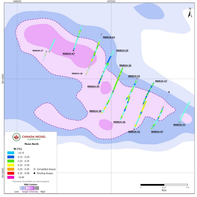
The Mann North target is approximately 1.5 kilometres long by 600 metres wide (0.9 square kilometres) (Figure 4). Drilling was completed during the summer of 2024 and consisted of a preliminary exploratory phase of 16 drillholes totaling 6,315 metres. The majority of these holes intersected long sections of peridotite, with minor dunite (Table 4) with nickel grades in the peridotite consistent with Crawford. The peridotites, however, have anomalous values of platinum (Pt) and palladium (Pd) over significant intervals, as seen on Table 5. Hole MAN24-31, for example, intersected 12.7 metres of 0.58 g/t Pt+Pd and MAN24-50 intersected 16.7 metres of 0.50 g/t Pt+Pd.
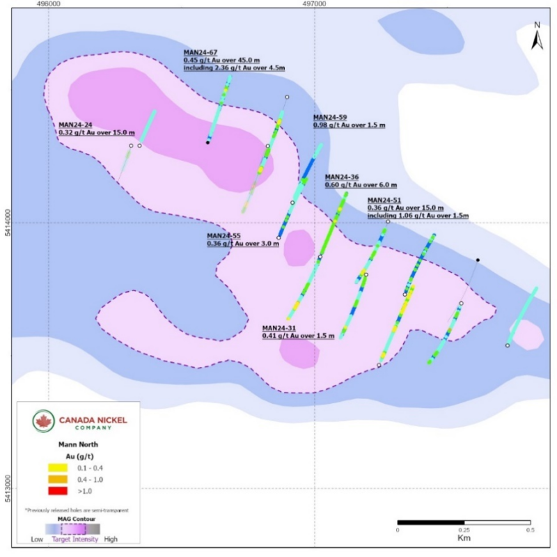
In addition to the anomalous Pt and Pd, the ultramafic units at Mann also have higher values for gold, especially near certain contacts. The intersections can be high grade and narrow such as in MAN23-12 which intersected 4.93 g/t gold over 1.5 metres or can be thicker and lower grade such as in MAN24-67 which intersected 0.45 g/t gold over 45.0 metres. Nine of 15 of the drillholes at Mann North assayed to date include gold intersections of 0.4 g/t gold or higher. Significant intersections are summarized in Table 6.
Assays are pending for three remaining holes.
Table 4 – Mann North drilling highlights
| Hole ID | From (m) | To (m) | Length (m)* | Ni % | Co % | Pd g/t | Pt g/t | Cr % | Fe % | S % |
| MAN24-24 | 39.0 | 109.5 | 70.5 | 0.15 | 0.010 | 0.004 | 0.003 | 0.43 | 6.77 | 0.061 |
| MAN24-31 | 28.4 | 519.0 | 490.6 | 0.18 | 0.012 | 0.013 | 0.022 | 0.38 | 6.88 | 0.061 |
| including | 57.0 | 72.0 | 15.0 | 0.30 | 0.014 | 0.044 | 0.024 | 0.28 | 6.47 | 0.280 |
| MAN24-36 | 21.0 | 408.0 | 387.0 | 0.21 | 0.012 | 0.012 | 0.010 | 0.50 | 6.93 | 0.063 |
| MAN24-46 | 18.8 | 312.5 | 293.7 | 0.17 | 0.012 | 0.005 | 0.007 | 0.40 | 7.54 | 0.028 |
| and | 327.9 | 399.0 | 71.1 | 0.17 | 0.014 | 0.012 | 0.008 | 0.39 | 8.25 | 0.057 |
| MAN24-47 | 18.0 | 402.0 | 384 | 0.18 | 0.012 | 0.006 | 0.008 | 0.48 | 7.36 | 0.035 |
| MAN24-50 | 21.5 | 280.6 | 259.1 | 0.15 | 0.012 | 0.004 | 0.005 | 0.45 | 7.54 | 0.024 |
| and | 313.5 | 390.0 | 76.5 | 0.18 | 0.013 | 0.010 | 0.011 | 0.41 | 7.29 | 0.051 |
| MAN24-51 | 45.0 | 171.0 | 126 | 0.16 | 0.013 | 0.008 | 0.010 | 0.44 | 7.76 | 0.030 |
| and | 196.0 | 402.0 | 206 | 0.16 | 0.012 | 0.005 | 0.005 | 0.34 | 7.25 | 0.032 |
| MAN24-53 | 15.0 | 402.0 | 387 | 0.11 | 0.012 | 0.007 | 0.010 | 0.33 | 8.07 | 0.032 |
| MAN24-55 | 17.4 | 177.8 | 160.4 | 0.18 | 0.013 | 0.005 | 0.005 | 0.53 | 7.56 | 0.046 |
| and | 352.5 | 402.0 | 49.5 | 0.19 | 0.012 | 0.007 | 0.017 | 0.36 | 6.67 | 0.039 |
| MAN24-59 | 31.5 | 402.0 | 370.5 | 0.15 | 0.012 | 0.010 | 0.011 | 0.38 | 7.19 | 0.044 |
| MAN24-63 | 132.5 | 267.0 | 134.5 | 0.20 | 0.012 | 0.019 | 0.016 | 0.38 | 7.34 | 0.072 |
| including | 142.5 | 156.0 | 13.5 | 0.34 | 0.012 | 0.060 | 0.031 | 0.14 | 7.20 | 0.020 |
| and | 311.2 | 462.0 | 150.8 | 0.18 | 0.012 | 0.005 | 0.006 | 0.43 | 7.20 | 0.024 |
| MAN24-67 | 15.6 | 420.0 | 404.4 | 0.15 | 0.012 | 0.025 | 0.021 | 0.36 | 7.72 | 0.039 |
| including | 327.0 | 348.0 | 21.0 | 0.23 | 0.013 | 0.081 | 0.043 | 0.55 | 7.79 | 0.141 |
Table 5 – Mann Properties PGM Highlights
| Hole ID | From
(m) |
To
(m) |
Length
(m) |
Pt+Pd
(g/t) |
Pd
g/t) |
Pt
(g/t) |
Ni
(%) |
Co
(%) |
Cr
(%) |
Fe
(%) |
S
(%) |
| MAN24-49 | 201.0 | 219.0 | 18.0 | 0.51 | 0.30 | 0.21 | 0.04 | 0.007 | 0.37 | 4.58 | 0.021 |
| MAN24-62 | 309 | 327 | 18.0 | 0.44 | 0.31 | 0.13 | 0.18 | 0.015 | 0.49 | 8.11 | 0.054 |
| MAN24-35 | 390.0 | 402.0 | 12.0 | 0.33 | 0.11 | 0.22 | 0.06 | 0.011 | 0.48 | 7.49 | 0.014 |
| MAN24-60 | 242.1 | 265.5 | 23.4 | 0.43 | 0.25 | 0.18 | 0.03 | 0.007 | 0.36 | 5.01 | 0.014 |
| and | 345.0 | 360.0 | 15.0 | 0.42 | 0.26 | 0.16 | 0.03 | 0.007 | 0.34 | 5.41 | 0.015 |
| MAN24-69 | 238.0 | 255.0 | 17.0 | 0.45 | 0.26 | 0.19 | 0.04 | 0.007 | 0.39 | 4.76 | 0.013 |
| MAN24-31 | 118.5 | 131.2 | 12.7 | 0.58 | 0.22 | 0.36 | 0.03 | 0.007 | 0.28 | 4.55 | 0.012 |
| MAN24-38 | 125.0 | 138.0 | 13.0 | 0.32 | 0.21 | 0.11 | 0.02 | 0.007 | 0.28 | 6.79 | 0.024 |
| and | 285.0 | 292.6 | 7.6 | 0.47 | 0.21 | 0.26 | 0.05 | 0.011 | 0.29 | 6.21 | 0.013 |
| and | 382.5 | 396.2 | 13.7 | 0.39 | 0.18 | 0.21 | 0.05 | 0.012 | 0.36 | 5.64 | 0.018 |
| MAN24-46 | 312.5 | 327.9 | 15.4 | 0.46 | 0.24 | 0.22 | 0.04 | 0.008 | 0.37 | 5.33 | 0.008 |
| MAN24-50 | 280.6 | 297.3 | 16.7 | 0.50 | 0.33 | 0.17 | 0.03 | 0.007 | 0.38 | 5.07 | 0.011 |
| MAN24-51 | 171.0 | 186.0 | 15.0 | 0.31 | 0.20 | 0.12 | 0.02 | 0.007 | 0.27 | 6.74 | 0.042 |
| MAN24-55 | 288.0 | 337.0 | 49.0 | 0.33 | 0.17 | 0.17 | 0.02 | 0.007 | 0.25 | 6.33 | 0.038 |
| MAN24-63 | 292.5 | 303.0 | 10.5 | 0.33 | 0.21 | 0.12 | 0.02 | 0.007 | 0.27 | 6.97 | 0.019 |
Figure 5 – Mann North
Figure 6 – Mann North Gold Highlights
Table 6 – Mann Properties Gold Highlights
| Hole ID | From
(m) |
To
(m) |
Length
(m) |
Au
(g/t) |
| MAN24-19 | 382.5 | 384.0 | 1.5 | 0.40 |
| MAN24-24 | 52.5 | 67.5 | 15.0 | 0.32 |
| MAN24-31 | 57.0 | 58.5 | 1.5 | 0.41 |
| MAN24-36 | 348.0 | 354.0 | 6.0 | 0.60 |
| including | 348.0 | 349.5 | 1.5 | 1.58 |
| MAN24-51 | 289.5 | 304.5 | 15.0 | 0.36 |
| Including | 300.0 | 301.5 | 1.5 | 1.06 |
| MAN24-55 | 396.0 | 399.0 | 3.0 | 0.36 |
| MAN24-59 | 139.5 | 141.0 | 1.5 | 0.51 |
| and | 274.5 | 276.0 | 1.5 | 0.98 |
| MAN24-67 | 115.5 | 160.5 | 45.0 | 0.45 |
| including | 118.5 | 121.5 | 3.0 | 1.15 |
| and | 147.0 | 151.5 | 4.5 | 2.36 |
Reaume
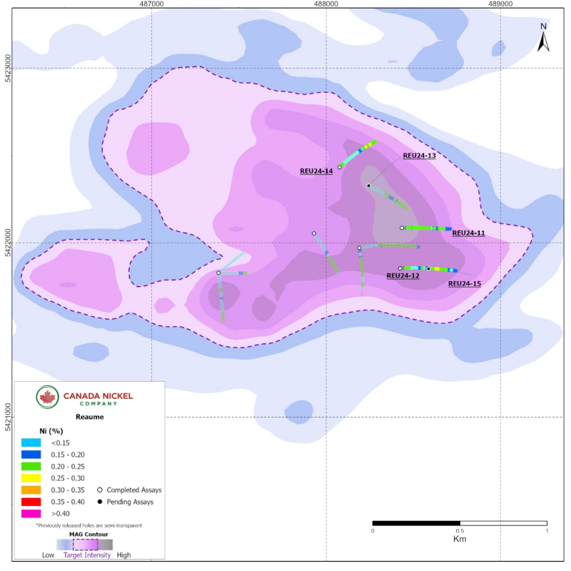
The Reaume property is located 20 kilometres northeast of Crawford, 15 kilometres southwest of Cochrane, and 55 kilometres northeast of Timmins. The property will form part of the ExploreCo subsidiary assets with Noble on an 80%-20% (Canada Nickel-Noble) ownership basis. Prior drill campaigns in 2022 had seasonal access constraints, however, in June 2024, the Company resumed exploration and intersected a mineralized portion of the ultramafic body consisting of moderate to strongly serpentinized peridotite containing spotty, coarse-grained awaruite mineralization in hole REU24-12 (Figure 7). This release contains the results of three drillholes at Reaume with assay results pending on two remaining holes.
Table 7– Reaume drilling highlights.
| Hole ID | From (m) | To (m) | Length (m)* | Ni % | Co % | Pd g/t | Pt g/t | Cr % | Fe % | S % |
| REU24-11 | 36.0 | 501.0 | 465 | 0.19 | 0.012 | 0.004 | 0.005 | 0.623 | 7.403 | 0.020 |
| REU24-12 | 40.3 | 561.0 | 520.7 | 0.19 | 0.013 | 0.003 | 0.006 | 0.588 | 7.375 | 0.026 |
| Including | 330.0 | 375.0 | 45 | 0.24 | 0.012 | 0.004 | 0.005 | 0.262 | 6.818 | 0.017 |
| REU24-14 | 18.0 | 40.5 | 22.5 | 0.23 | 0.015 | 0.005 | 0.003 | 0.403 | 7.743 | 0.047 |
| and | 86.3 | 119.0 | 32.7 | 0.03 | 0.007 | 0.189 | 0.159 | 0.313 | 6.063 | 0.015 |
| and | 147.0 | 402.0 | 255 | 0.18 | 0.013 | 0.009 | 0.013 | 0.543 | 7.880 | 0.037 |
| including | 303.0 | 307.5 | 4.5 | 0.44 | 0.018 | 0.067 | 0.047 | 0.680 | 8.723 | 0.130 |
*True width undetermined. All lengths are drillhole lengths.
Table 8 Reaume PGM Highlights
| Hole ID | From
(m) |
To
(m) |
Length
(m) |
Pt+Pd
(g/t) |
Pd
g/t) |
Pt
(g/t) |
Ni
(%) |
Co
(%) |
Cr
(%) |
Fe
(%) |
S
(%) |
| REU24-14 | 86.3 | 119.0 | 32.7 | 0.35 | 0.19 | 0.16 | 0.025 | 0.007 | 0.31 | 6.06 | 0.015 |
| including | 100.5 | 105.0 | 4.5 | 0.67 | 0.43 | 0.24 | 0.022 | 0.006 | 0.33 | 5.56 | 0.012 |
Figure 7 – Reaume
Table 9: Drillhole Orientation
| Hole ID | Easting (mE) | Northing (mN) | Azimuth (⁰) | Dip (⁰) | Length (m) |
| REID | |||||
| REI24-41 | 457554 | 5404310 | 0 | -60 | 706 |
| REI24-43 | 457350 | 5404200 | 70 | -60 | 696 |
| REI24-45 | 457859 | 5403898 | 90 | -60 | 668 |
| REI24-46 | 456306 | 5404370 | 180 | -50 | 702 |
| REI24-47 | 457765 | 5404100 | 90 | -60 | 702 |
| REI24-48 | 456860 | 5404060 | 180 | -55 | 702 |
| REI24-50 | 457817 | 5404256 | 90 | -60 | 600 |
| REI24-52 | 457350 | 5404200 | 180 | -60 | 759 |
| MANN WEST | |||||
| MAN24-33 | 496260 | 5412289 | 35 | -50 | 396 |
| MAN24-37 | 496144 | 5412134 | 35 | -50 | 402 |
| MAN24-45 | 495656 | 5412189 | 40 | -50 | 402 |
| MAN24-49 | 495656 | 5412189 | 230 | -50 | 402 |
| MAN24-54 | 495796 | 5412336 | 40 | -50 | 402 |
| MAN24-58 | 495641 | 5412486 | 40 | -65 | 351 |
| MAN24-62 | 495296 | 5412441 | 50 | -50 | 501 |
| MANN CENTRAL | |||||
| MAN24-19 | 496800 | 5410400 | 0 | -50 | 397 |
| MAN24-22 | 498724 | 5410530 | 350 | -50 | 552 |
| MAN24-26 | 498360 | 5410370 | 0 | -50 | 399 |
| MAN24-32 | 498466 | 5410751 | 180 | -50 | 402 |
| MAN24-34 | 498970 | 5410764 | 165 | -50 | 402 |
| MAN24-35 | 497509 | 5410702 | 180 | -50 | 402 |
| MAN24-39 | 498466 | 5410751 | 215 | -55 | 171 |
| MAN24-40 | 497698 | 5410729 | 180 | -50 | 396 |
| MAN24-43 | 498265 | 5410644 | 180 | -50 | 402 |
| MAN24-44 | 497880 | 5410638 | 180 | -50 | 402 |
| MAN24-52 | 498450 | 5410430 | 180 | -50 | 400 |
| MAN24-56B | 498260 | 5410430 | 180 | -50 | 402 |
| MAN24-60 | 498445 | 5410230 | 180 | -50 | 360 |
| MANN NORTH | |||||
| MAN24-24 | 496342 | 5414290 | 20 | -50 | 237 |
| MAN24-31 | 497243 | 5413464 | 20 | -50 | 519 |
| MAN24-36 | 497022 | 5413872 | 20 | -50 | 408 |
| MAN24-46 | 497195 | 5413805 | 200 | -50 | 402 |
| MAN24-47 | 497340 | 5413730 | 20 | -50 | 402 |
| MAN24-50 | 497552 | 5413697 | 200 | -50 | 402 |
| MAN24-51 | 497277 | 5414004 | 200 | -50 | 402 |
| MAN24-53 | 497727 | 5413538 | 20 | -50 | 402 |
| MAN24-55 | 496866 | 5413943 | 20 | -50 | 402 |
| MAN24-59 | 496917 | 5414076 | 20 | -50 | 402 |
| MAN24-67 | 496599 | 5414301 | 20 | -50 | 420 |
| REAUME | |||||
| REU24-11 | 488435 | 5422086 | 90 | -50 | 501 |
| REU24-12 | 488424 | 5421854 | 90 | -50 | 561 |
| REU24-14 | 488077 | 5422433 | 45 | -50 | 402 |
Quality Assurance and Control, Drilling and Assaying
Edwin Escarraga, MSc, P.Geo., a “qualified person” as defined by National Instrument 43-101, is responsible for the on-going drilling and sampling program, including quality assurance (QA) and quality control (QC). The core is collected from the drill in sealed core trays and transported to the core logging facility. The core is marked and sampled at 1.5 metre lengths and cut with a diamond blade saw. One set of samples is transported in secured bags directly from the Canada Nickel core shack to Actlabs Timmins, while a second set of samples is securely shipped to SGS Lakefield for preparation, with analysis performed at SGS Burnaby or SGS Callao (Peru). All are ISO/IEC 17025 accredited labs. Analysis for precious metals (gold, platinum and palladium) are completed by Fire Assay while analysis for nickel, cobalt, sulphur and other elements are performed using a peroxide fusion and ICP-OES analysis. Certified standards and blanks are inserted at a rate of 3 QA/QC samples per 20 core samples making a batch of 60 samples that are submitted for analysis.
Qualified Person and Data Verification
Stephen J. Balch P.Geo. (ON), VP Exploration of Canada Nickel and a “qualified person” as such term is defined by National Instrument 43-101, has verified the data disclosed in this news release, and has otherwise reviewed and approved the technical information in this news release on behalf of Canada Nickel Company Inc .
Wayne Holmstead P.Geo (ON), a “qualified person” as defined by National Instrument 43-101, has reviewed the data disclosed in this news release, and has otherwise reviewed and approved the technical information in this news release on behalf of Noble.
About Noble Mineral Exploration Inc.:
Noble Mineral Exploration Inc. is a Canadian-based junior exploration company which, in addition to its shareholdings in Canada Nickel Company Inc., Homeland Nickel Inc., Go Metals Corp. and Lode Gold Resources Inc . , and its interest in the Holdsworth gold exploration property in the area of Wawa, Ontario, will continue to hold ~25,000 hectares of mineral rights in the Timmins-Cochrane areas of Northern Ontario known as Project 81, as well as an additional 20% interest in ~11,000 hectares in the Timmins area and ~175 hectares of mining claims in Central Newfoundland. Project 81 hosts diversified drill-ready gold, nickel-cobalt and base metal exploration targets at various stages of exploration. It will also hold its ~14,600 hectares in the Nagagami Carbonatite Complex and its ~4,600 hectares in the Boulder Project both near Hearst, Ontario, as well as ~3,700 hectares in the Buckingham Graphite Property, ~10,152 hectares in the Havre St Pierre Nickel, Copper, PGM property, and ~482 hectares in the Cere-Villebon Nickel, Copper, PGM property, all of which are in the province of Quebec. More detailed information is available on the website at:
www.noblemineralexploration.com.
Noble’s common shares trade on the TSX Venture Exchange under the symbol “NOB”.
Cautionary Statement:
Neither TSX Venture Exchange nor its Regulation Services Provider (as that term is defined in the policies of the TSX Venture Exchange) accepts responsibility for the adequacy or accuracy of this release. No stock exchange, securities commission or other regulatory authority has approved or disapproved the information contained herein.
The foregoing information may contain forward-looking statements relating to the future performance of Noble Mineral Exploration Inc. Forward-looking statements, specifically those concerning future performance, are subject to certain risks and uncertainties, and actual results may differ materially from the Company’s plans and expectations. These plans, expectations, risks and uncertainties are detailed herein and from time to time in the filings made by the Company with the TSX Venture Exchange and securities regulators. Noble Mineral Exploration Inc. does not assume any obligation to update or revise its forward-looking statements, whether as a result of new information, future events or otherwise.
Contacts:
H. Vance White, President
Phone: 416-214-2250
Fax: 416-367-1954
Email: [email protected]
Investor Relations: [email protected]
https://noblemineralexploration.com/

